A worldwide community photographing and learning about wildlife

Project Noah Nature School

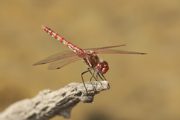
Sympetrum corruptum
A small farm pond that is usually about 0.5 acres in surface area, but only had a few inches left in it at the time of observation due to severe drought.
Due to the lack of accuracy with the mapping aspect of this application (i.e. only allows you to click on a street address and not the actual location), the location data of this sighting is quite inaccurate. This is frustrating and project noah should address this and allow observers to drop a location exactly at the point of observation.

Spotted on Oct 14, 2011
Submitted on Nov 7, 2011


![[Sympetrum fonscolombii]](https://lh4.ggpht.com/jL2Mu9wH0iczRaz6W0S0c0HAVr_YLXSKhfRw1MA5-vJn2mzQTaOO8U7YG6EtZN_s3jZSH5QfB8V171gVaik=s62-c)


10 Comments
thanks!
this is Peter's e-mail
peter@projectnoah.org
this is Yasser's e-mail
yasser@projectnoah.org
Since I'm new to P Noah, I'm not sure how to contact them directly. Would you suggest I contact support with ideas and it will get to them? Any suggestions on how to reach them would be appreciated. I'd like to offer some ideas for improvement. Thanks!
John
If you have some useful ideas and suggestions please write to Yasser or Peter.
Your feedback would be appreciated.
I for one am still very puzzled.
Thanks! I still think the app could add to the profile a setting to buffer the locations for a person's sightings or not. Incidentally I was able to make the location more accurate with the app's mapping feature on my phone than I could from the website.
i practice caution in terms of the location.
@irons Welcome to Project Noah.
Love your Meadowhawk spotting!
I agree with Emma. What if the user forgets to buffer the location?
I understand that concern but there could easily be a "buffer the location" feature for those concerned about that. The app iNaturalist allows for exact locations or buffered ones. Overall I like this app but the lack of mapping accuracy is a severe limitation and if it's not corrected i will stop using the app.
@ irons, may sound stupid ,but it makes me happy that the exact location is not revealed. i worry about poachers and animal traders etc misusing the data.