A worldwide community photographing and learning about wildlife

Project Noah Nature School

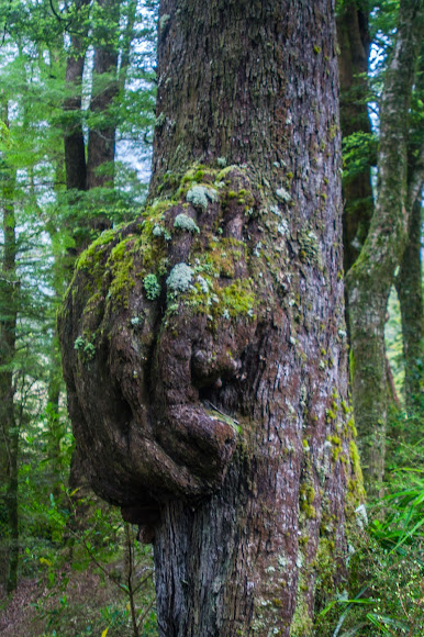
Fjordlands National Park, on the way to Milford Sound.
Fiordland National Park occupies the southwest corner of the South Island of New Zealand. It is by far the largest of the 14 national parks in New Zealand, with an area of 12,607 square kilometres (4,868 sq mi),[1] and a major part of the Te Wahipounamu World Heritage site. The park is administered by the Department of Conservation. During the cooler past, glaciers carved many deep fiords, the most famous (and most visited) of which is Milford Sound. Other notable fiords include Doubtful Sound and Dusky Sound. The retreat of the glaciers after the ice age left behind U-shaped valleys with sheer cliffs and as a result Fiordland's coast is steep and crenellated, with some of the 15 fiords reaching as far as 40 kilometres (25 mi) inland. The southern ranges of the Southern Alps cover most of Fiordland National Park and combined with the deep glacier-carved valleys present a highly inaccessible landscape. At the northern end of the park, the Darran Mountains contain several peaks rising to over 2,500 metres (8,200 ft), with views of Mount Aspiring / Tititea to the north in the neighbouring Mount Aspiring National Park. Further south, the Franklin Mountains, Stuart Mountains, and Murchison Mountains reach around 2,000 metres (6,600 ft), with the peaks diminishing in height from north to south. The Kepler, Dingwall, Kaherekoau, Princess and Cameron Mountains further south only reach 1,500–1,700 metres (4,900–5,600 ft). The carving action of the glaciers has succeeded in cutting off islands from the mainland, leaving two large uninhabited offshore islands, Secretary Island and Resolution Island, as well as many smaller ones. Although these glaciers are long-gone, a few small glaciers and permanent snow fields remain, with the southernmost glacier situated below Caroline Peak. Several large lakes lie wholly or partly within the park's boundaries, notably Lake Te Anau and Lake Manapouri, both on the western boundary of the national park, as well as the southern lakes Lake Monowai, Lake Hauroko, and Lake Poteriteri. All of these lakes exhibit the topography typical of glacier-carved valleys, with Lake Te Anau and Lake Manapouri in particular having several arms similar in look to the fiords on the west coast of the park. The Sutherland Falls, to the southwest of Milford Sound on the Milford Track, are among the world's highest waterfalls. Other tall waterfalls in the park include Browne Falls, Humboldt Falls, Lady Alice Falls, and Bowen Falls, as well as countless temporary waterfalls in the fjords that come alive following rainfall. Prevailing westerly winds blow moist air from the Tasman Sea onto the mountains; the cooling of this air as it rises produces a prodigious amount of rainfall, exceeding seven metres in many parts of the park. This supports the lush temperate rain forests of the Fiordland temperate forests ecoregion. Milford Sound / Piopiotahi is a fiord in the south west of New Zealand's South Island within Fiordland National Park, Piopiotahi (Milford Sound) Marine Reserve, and the Te Wahipounamu World Heritage site Rudyard Kipling had previously called it the eighth Wonder of the World. The fiord is most commonly accessed via road (State Highway 94) by tour coach, with the road terminating at a small village also called Milford Sound. As a fiord, Milford Sound was formed by a process of glaciation over millions of years. The village at the end of the fiord is also known as Milford Sound. Milford Sound runs 15 kilometres inland from the Tasman Sea at Dale Point (also named after a location close to Milford Haven in Wales)—the mouth of the fiord—and is surrounded by sheer rock faces that rise 1,200 metres (3,900 ft) or more on either side. Among the peaks are The Elephant at 1,517 metres (4,977 ft), said to resemble an elephant's head,[7] and The Lion, 1,302 metres (4,272 ft), in the shape of a crouching lion. Milford Sound sports two permanent waterfalls, Lady Bowen Falls and Stirling Falls. After heavy rain temporary waterfalls can be seen running down the steep sided rock faces that line the fiord. They are fed by rain water drenched moss and will last a few days at most once the rain stops.[citation needed. With a mean annual rainfall of 6,412 mm (252 in) each year, a high level even for the West Coast, Milford Sound is known as the wettest inhabited place in New Zealand and one of the wettest in the world. Rainfall can reach 250 mm (10 in) during a span of 24 hours. The rainfall creates dozens of temporary waterfalls (as well as a number of major, more permanent ones) cascading down the cliff faces, some reaching a thousand metres in length. Smaller falls from such heights may never reach the bottom of the sound, drifting away in the wind. Accumulated rainwater can, at times, cause portions of the rain forest to lose their grip on the sheer cliff faces, resulting in tree avalanches into the fiord. The regrowth of the rain forest after these avalanches can be seen in several locations along the sound.

Spotted on Nov 6, 2016
Submitted on Jun 3, 2021


2 Comments
I looked up burl and I agree, thanks. posting renamed.
Perhaps it's a burl, jazz.man. https://en.m.wikipedia.org/wiki/Burl#:~:....